
Precision Ag
Supporting Smarter Field Management
Midwest Ag Professionals works with producers across Kansas, Oklahoma, Nebraska, Colorado, and Missouri, helping simplify acreage reporting, field mapping, and operational documentation through practical Precision Ag services.
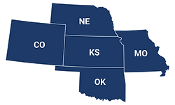

Precision Ag services designed to help producers stay organized, improve reporting accuracy, and better manage field-level information throughout the season.
Through trusted Precision Ag resources and industry-leading technology, Midwest Ag Professionals helps producers navigate equipment setup, reporting systems, precision mapping, and data sharing with greater confidence and accuracy.
Precision Ag technology and reporting systems can feel overwhelming at first, especially as agriculture continues moving toward more data-driven reporting and documentation. Our team is here to help simplify the process and support producers with practical guidance, trusted resources, and tools designed to make reporting easier, more accurate, and less stressful.
Solutions Designed for Your Operation

Improve Reporting Accuracy

Simplify Acreage Documentation

Access Better Field Data

PRECISION AG SERVICES & GPS MAPPING
Why Precision Ag Matters
More Accurate Reporting
GPS-based mapping and precision data help improve acreage reporting and reduce errors.
Better Recordkeeping
Digital planting and harvest records create stronger documentation for reporting and claims.
Improved Efficiency
Electronic reporting tools help simplify paperwork and streamline crop insurance reporting.
Stronger Risk Management
Accurate field data helps support better decisions related to coverage, production history, and long-term planning.
Available Precision Ag Services
Field Mapping Services
Visual field maps designed to help organize acreage, field boundaries, reporting, and operational records.
Acreage Reporting Support
Tools and reporting assistance that help reduce common acreage reporting errors and improve accuracy.
Printed Field Maps
Compact printed maps designed for use throughout planting, spraying, fertilizer application, and harvest.
Wall Maps
Large-format maps that provide a high-level view of your operation for office use and planning.
Who Precision Ag Is Best For
Precision Ag services are especially valuable for:
Producers using modern planting and yield-monitoring equipment
Operations wanting cleaner records and better organization
Farmers looking to maximize accuracy in their crop insurance reporting
Growing operations that want to improve efficiency and long-term management
Whether you farm a few hundred acres or manage a large operation, Precision Ag tools can help simplify reporting, improve accuracy, and give you confidence that your records are backed by reliable data.
